
Software Ugeo
The advanced platform for your Geomarketing research
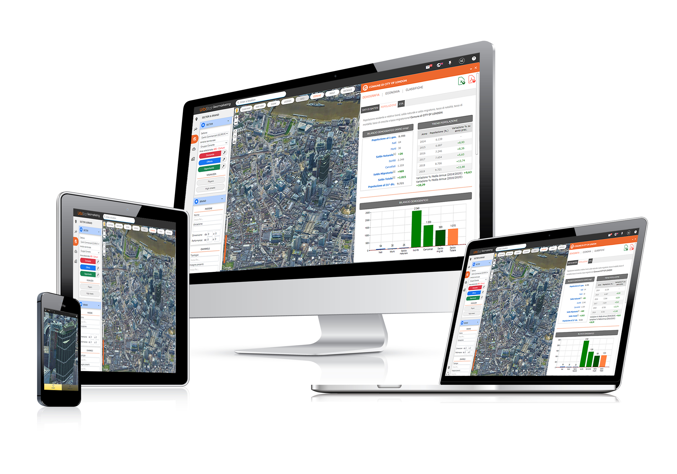
Features
Online
No installation. Automatically updated. Working with many devices (smartphone, tablet, computer, touchwall).
Multi Countries
Geomarketing analysis in more then 25 Countries.
Always updated
Demographic data, socio-economic data and industry players are always available at the latest update.
Google Maps
Based on Google Map it has a user friendly interface.
24h / 24h
Always accessible everywhere you are.
Multilanguage
6 languages available.
Modulable
Make your subscription with the functions, databases and countries according to your needs.
Google partner
It uses Google technologies to query, georeferencing, and displaying large amounts of data.
Modules / Functionalities
- Administrative Area
- Catchment Area
- Competition & Performances
- Sector & Brands
- User Database
- Real Estate
- Mobile Data
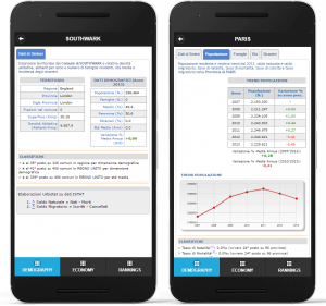
AdminInfo Module
It provides socio-demographic and economic information’s on various administrative levels: by regions, provinces, municipalities and Zip Code (Italy).
In particular maps, tables and charts are reported related to:

- inhabitants
- families
- age classes
- strangers
- occupation
- income
- consumption
- businesses
Thematic Maps Module
It allows you to create thematic maps on various administrative levels based on data directly imported by the user.
A series of default maps are also available related to socio-demographic and economic variables on all administration levels.

Target Module
Analyzes the catchment area from the following standpoints::
- socio-demographic: inhabitants, families, foreigners, age and gender classes;
- occupational: employed, unemployed, manpower, and unemployment rate;
segmenting outputsby time isochrones/ isometrics as well as by municipality / Zip Code (Italy). Furthermore it provides comparisons on previous variables, including the catchment area and the municipality / region / province / state where the location is based in.

Economics Module
Analyzes the Catchment Area from an economic point of view: index numbers of income and consumption, income levels and consumption by product category, segmenting the output by isochrones and/or isometrics and municipality / Zip Code (Italy).

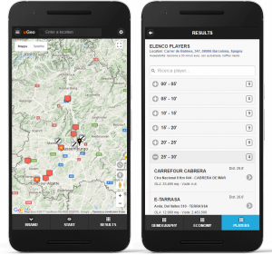
Player Module
Provied databases of competition in the area of interest. The currently available categories are:
- Shopping Centre, Retail Parks, Factory Outlets, Pipelines (CC/RP/FO), Hypermarkets, Fashion etc.
- Other available data (Hypermarket, clothing, etc)

Overlap Module
Analyzes the competitive tension present within a catchment area, estimating how much the resident population is subject to the attraction exerted by individual competitors and providing feedback on areas of overlapping.
It also allows you to compare multiple locations simultaneously and then identify the Best Location. The above mentioned dynamics are represented on the map within the intersection basin.

Scenarios Module
Allows to simulate through the application of modelling (gravitational type):
- the current competitive scenario, providing estimates based on systematized capacity comparative attractions analysis of the various players, on the theoretical origin of proper customers and / or on current market shares;
- the future scenario, determined by the arrival of a new competitor and / or enlargement of an existing structure and / or the closure of a player; possible estimates (in relation to all systematized competitors) regarding new performances, eventual losses and changes in the Basin of Influence.

Audit Module
Allows you to analyze data concerning the source of proper customers and its performance.
Data can be “loaded” on the platform, directly by the user and processed instantaneously.

Fidelity Cards Module
This module allows you to analyze the the Fidelity Cards data: punctual representation on map of individual Fidelity Cards, heat maps, segmentation of the fidelities in purchase clusters, analyzes of fidelity / infidelity within the same network considering the family spending power.
In addition, it is possible to analyze the trend of purchasing behavior (spending pattern, the average receipt, market shares, etc.) with reference to all the various areas of interest (Municipality, Zip Code, Catchment Areas, Manual Areas, etc.) both to selected time intervals (monthly basis).

MS Model Module
This module allows you to apply gravitational functions (exponential) and to estimate the market share and the prospective revenues of a specified location.
The function parameters are editable and allow the user to check the results (output) in real time.

Prediction Model Module
This module allows you to estimate the turnover of a new sales point of a specified chain by using inferential statistical models (eg. Multiple regression models). It is particularly suitable in case of chains that presents small/medium-size sales areas that respond less effectively to pure gravitational models.
The tailored equation, implemented on uGeo platform (for an immediate and easy use) and specific for each individual chain, is the result of off-line analysis which in addition to identify and measure the variables that significantly affect the turnover, also allows to analyze and qualify the existing network performance.

Sector Module
Analysis and representation through “heat maps” for all administrative levels (regions, provinces and municipalities) by the distribution on the territory:
- Demand, population / potential marketplace (for all sectors);
- Offer, competitors and related coverage of the territory;
- Opportunities, identification of areas with the greatest potential.

Brand Module
Thanks to this module you can make extractions/groups/filters of Shops and/or aggregated commercial structures (Shopping Centres, Retail Parks, Factory Outlets, etc.) based on a variety of user-selectable criteria: merchandise sector, sign, surface, performance, geographical area, etc.
The Output will be returned and on map (with icons that show the sign of the sales point and/or category of membership) and in tabular format exportable to Excel and/or Acrobat Pdf format.

High Streets & Walk Score Module
It allows you to represent and classify in terms of retail potential the major “fashion street” within each municipality in the Italian territory.
It is also possible obtain information about pedestrian flows and related daily/weekly/monthly/yearly -trends of about 1,000 roads pedestrian traffic segments in the major Italian historical centers.

User Database Module
Through this form, the user can upload their data to the platform. Starting from:
- Excel file
- Kml
- Country administrative data
- a simple copy-paste
you can import your own databases into uGeo and view them on the map. An advanced filter and detail windows allow a deeper analysis of the data.
It is possible to modify your personal database at any time, of which UrbiStat guarantees confidentiality and periodic backups. It is also possible to have databases shared between multiple uGeo users and customize their display.
UrbiStat offers features such as geocoding of address lists for precise location on the map.


Real Estate Module
This module is aimed at companies operating in the real estate sector and offers advanced analysis of the territory and buildings of a specific area. In fact, through a catchment area or basin you can have various information such as:
- sale and lease values of the Omi Zones (divided by type);
- trend Omi Zones;
- families number;
- integration with the user’s database (properties sold or in their own portfolio for sale / rent and related attributes);
- positioning on the map of the properties in the user’s database;
For more information contact us by sending an e-mail to info@urbistat.com

Module Mobile
The uGeo platform contains information related to the mobility of approximately 13 million Italian devices for which we can analyze position (latitude/longitude), gender and age of the users.
Together with the elaborations/modules already available into the system, the Mobile Module makes it possible to:
- carry out analyzes relating to the traffic or the affluence of a specific area;
- estimate the visitors of a given structure or area;
- estimate the dwelling time or the returning frequency of the customers;
- define the place of origin and/or destination of the customers;
- study the overlapping levels with competitors or other structures of interest.


All the analyzes within the uGeo platform are realized through the development and application of econometric and statistical-gravitational models elaborated by URBISTAT and will be explained to the client more during a meeting.


uGeo for smartphone
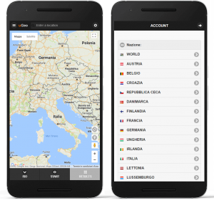
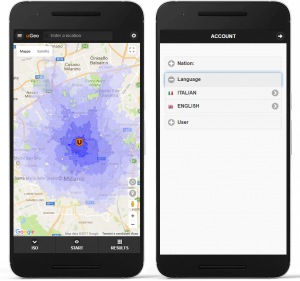
Download uGeo for your smartphone Android
uGeo is available on Play Store. Download the app for your smartphone to analyze the territory wherever you are.
Module Isocrone, Brand and Admininfo are available for registered user.
![]()
Countries available
more than 35 countries
| Available Countries: | |
|
|
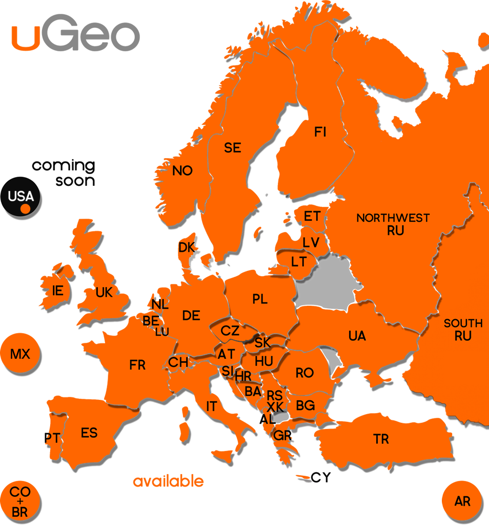
Modules available by Country
Prices
We offer personalized subscriptions plans. Write us your needs and we will give you a free quotation.
Contact UsRequest a Demo
Custom Geomarketing Software for Client Needs
UrbiStat, leveraging the experience and multiple functionalities of uGeo, supports the creation of fully customized geomarketing solutions tailored to the specific needs of each client.
In addition to the standard uGeo solution, UrbiStat offers the possibility of creating and personalizing geomarketing software perfectly adapted to specific requirements. Geomarketing processes and topics can be vast and complex, but with software customization, it is possible to simplify everything, such as the graphical interface, by focusing solely on the essential features for the business. Furthermore, UrbiStat allows for the integration of the client’s unique colors and visual elements into the software, ensuring a user experience that is both unique and consistent with the company’s brand image.

Data visualization can be based on information provided by the client, with the addition of territorial data such as postal codes, census sections, provinces, and regions. The software is accessible online via email and password, allowing for the management of different user levels, from administrators to basic users, enabling specific functionalities based on the role.
Fill out the form on the following page to get in touch with one of our experts.